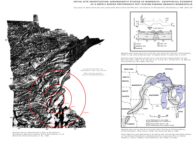
Left image group: Initial Site
Investigation: Aeromagnetic Studies Of Minnesota - Geophysical
Evidence of a Deeply Buried Proterozoic Rift System Passing Beneath
Minneapolis.
Left Image: Shaded-relief
Aeromagnetic Map of Minnesota, Minnesota Geologic Survey State Map
Series, S-18, Modified from Chandler, V.
W., 1991; concentric red rings on image: 25 mi., 50 mi., 100 mi.,
radius from Minneapolis.
Right/Top Image:
Generalized cross-section of the Mid continent Rift System (after
Gibson, 1979) in the Lake Superior area. Numbers refer to densities
in g/cm3. Adapted from "The Role of Rifting in the Tectonic
Development of the Mid continent, USA," G. R. Keller, E. D.Lidiak,
W. J. Hinze and L. W. Braile, Tectonophysics, 94 (1983), 391-412.
Right/Bottom Image: Generalized
map of the Mid continent Rift System of North America, after Craddock,
1972, Halls, 1978, and Hinze and
Wold,
1982.
From "Geologic
and Geochemical Evidence for the Nature and Development of the Middle
Proterozoic (Keweenwan) Mid-continent Rift of North America," John
C. Green, Tectonophysics, 94 (1983), 413-437. |
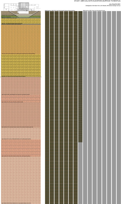
Center: Initial Site Studies:UMN-Rapson
Site Elevation (Surface to Mantle)
Section beneath Rapson Hall reveals Proterozoic volcanics, as inspiration for Inversion2:
Dark Matter (Proterozoic/Holocene) I and II, and an extension of the rift system exposed as anorthositic gabbro at the Mesabi Black quarry in northern, MN, where material was excavated for SITE INDEX.
QUATERNARY:
35 feet Quaternary terrace sand, gravelly sand, silty sand
25 feet
thickover 10 feet of till.
ORDOVICIAN:
5 feet Decorah Shale (mostly eroded):
30 feet Platteville Formation: Limestone and dolostone.
5 feet Glenwood Formation: Shale and sandstone.
165 feet St. Peter Sandstone: Fine- to medium grained sandstone
with minor shale and siltstone.
125 feet Prairie du Chien Group: Dolostone and minor sandstone.
UPPER
CAMBRIAN:
100 feet Jordan Sandstone: Fine-, medium- and coarse-grained
sandstone.
40 feet St. Lawrence Formation: Dolomitic siltstone.
140 feet Franconia Formation: Very fine- to fine sandstone
and siltstone,glauconitic.
65 feet Ironton and Galesville Sandstone: Fine- to medium
grained sandstone.
95 feet Eau Claire Formation: Siltstone, shale, very-fine
grained sandstone.
260 feet Mt. Simon Sandstone: Fine- to coarse-grained sandstone,
minor shale
.MIDDLE PROTEROZOIC:
2.7 - 4 km Solor Church Formation: Red-brown shale and lithic
sandstone. (8860 -13125 feet)
About 3 km Mid Proterozoic volcanic rock. (9800 feet)
1065 feet to the
base of the Paleozoic formations
9925 to 14190 feet to the base of the Solar Church Formation.
Data supplied
by:
John Mossler, Minnesota Geological Survey
|
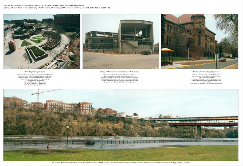
Right image group: Initial Site Studies:
Geologic Analysis of UMN Campus and Selected Buildings
Top Left Image:
Civil Engineering Complex: Holocene structure of varied composition
with 1-7 floor penetration into Quaternary and Paleozoic sediments:
Building: Brick - local altered Paleozoic sediment. Site: differentiated
glacial till - Quaternary; Decorah Shale - Ordovician; Platteville
Formation - Ordovician; St. Peter Sandstone - Ordovician; Parie
du Chien Group - Ordovician.
Top Center Image:
College of Architecture and Landscape Architecture;
Holocene structure of varied composition resting on Quaternary
sediments with shallow penetration. Original building: Brick
- local altered Paleozoic sediment; New Addition: Concrete - local
altered Cambrian sediment; Copper Sheathing - Chilean altered metamorphic rock; Site: same as adjacent Civil Engineering Complex.
Top Right Image:
Pillsbury Hall: Geology Department Holocene structure of primarily
Proterozoic sediments resting on Quaternary sediments with shallow
penetration. Building: Fond du Lac and Hinckley sandstone: Keweenawan
Supergroup, late Proterozoic Era, Northern MN. Site: same as adjacent
Civil Engineering Complex.
Bottom Image:
Mississippi River section (looking east): Holocene structures (UMN
campus) above late Cenozoic glacial sediments and Paleozoic marine
sediments (see Civil Eng. Complex, above). |