Yerba Buena Complex - Phase I
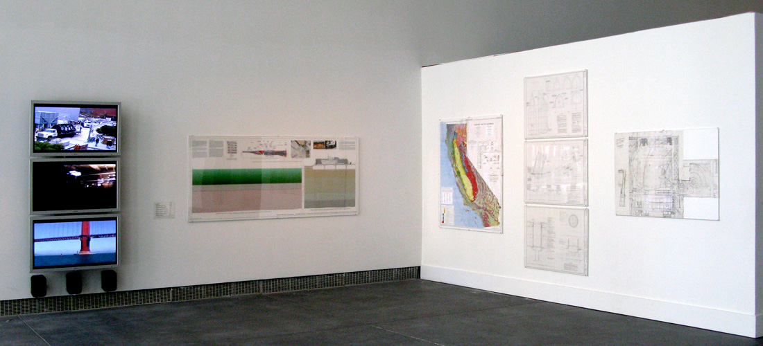
Detail View in YBCA Main Gallery showing 3-Channel Video, Studies and Design Drawings
Bay Area Now 5 / Inside-Out, Yerba Buena Center for the Arts, San Francisco, CA 2008
Left image: left to right:
Yerba Buena Complex: Facies III; (plasma 1 - top), 45:00 single channel video/sound on DVD, 1993-2008
Yerba Buena Complex: Facies II; (plasma 2 - middle); 45:00 single channel video/sound on DVD, 1991-2008
Yerba Buena Complex: Facies I; (plasma 3 - bottom); 45:00 single channel video/sound on DVD, 1993-2008
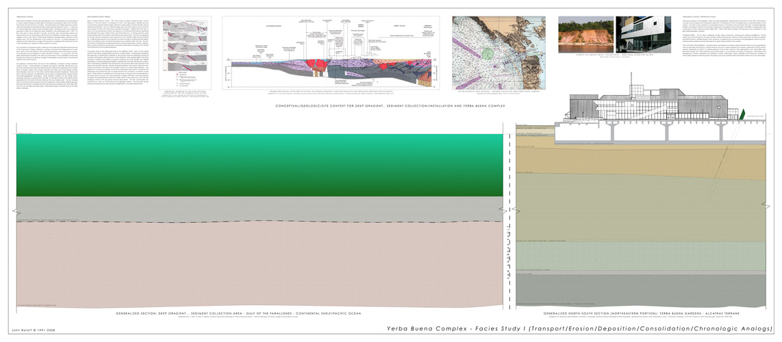
Yerba Buena Complex - Facies Study (Transport/Erosion/Deposition/Consolidation/Chronologic Analogs); digital print on drafting film, 42" x 96", 2008
Study: Golden Gate Sediment Origins; ink, water color, collage, existing map, 59" x 54", 1993-2008
Yerba Buena Gardens Ship Sculpture, Sheet AD-1 (top); pencil, ink on vellum, 30" x 42", 1993
Yerba Buena Gardens Ship Sculpture Sheet AD-2 (middle); pencil, ink on vellum, 30" x 42", 1993
Yerba Buena Gardens Ship Sculpture Sheet AD-5 (bottom); pencil, ink on vellum, 30" x 42", 1993
Sculpture Proposal - Viewport Plan; xerox and pencil on drafting film, 35" x 52 1/2", 1991
Right image:
Yerba Buena Complex - Facies Study (Transport/Erosion/Deposition/Consolidation/Chronologic Analogs)
The sediment collected in 1993, from the Gulf of the Farallones, as shown in the bottom of the 3-channel video sequence indicated above, Yerba Buena Complex: Facies I, entrained in Deep Gradient /Suspect Terrain.., whose diversity of minerals and organic materials, derived from erosional and transport processes that theoretically encompass the watershed of the Golden Gate, including: eastern and southern Klamath Mountains and Coast Range, western Sierra Nevadas, and much of the Great Central Valley and Marin Headlands. These sediments (and by extension, all sediments) may be seen as representatives of past terrains and paleo-geographic landscapes. Those sediments washed out the Golden Gate, seemingly collected, for placement in the ship, on the alien surface of the Salinian Block, separated from the North American Plate by the San Andreas fault. The drawing in the installation, Study: Golden Gate Sediment Origins, is an altered geology map of California, depicting the watershed and theoretical sediment origin of materials passing through the Golden Gate.
|
Yerba Buena Complex: Facies II, the video in the middle of the 3-channel sequence, is edited from footage taken during a walkthrough of the Yerba Buena site under construction in 1991.
Yerba Buena Complex: Facies III, the video at the top of the 3-channel sequence, is of the installation of Deep Gradient/Suspect Terrain.., 1993, and the placing of the Continental Shelf sediment within the ship, shown being gathered in the bottom video of the sequence. There is also a sequence showing the location and viewing of the two view-ports installed as part of the 1993 project.
|
Video Credits:
Yerba Buena Complex: Facies III; (plasma 1 - top)
Videography: Ann Wettrich, Greg Volker; Editing: John Roloff;
Project Assistance: Mark Tompson, Greg Volker, Ann Wettrich
Installation/Engineering: Wes-Co Insdustries, NGA Industries, Santos & Urrutia Associates
Commissioned: San Francisco Redevelopment Agency
Yerba Buena Complex: Facies II; (plasma 2 - middle)
Videography: John Roloff; Editing: John Roloff
Contractors/Design: (partial list) Turner Construction, MGA Partners,
Omi/Lang Associates
Yerba Buena Complex: Facies I; (plasma 3 - bottom)
Videography: Ann Wettrich, John Roloff; Editing, John Roloff
Project Assistance: Tim Collins, Ann Wettrich, Gary Rodgers, Capt: "The Seal"
Right image sources: upper left - right, lower right - left:
SEQUENTIAL DIAGRAM OF THE PLATE-TECTONIC EVOLUTION OF THE SAN ANDREAS FAULT SYSTEM,
adaped from: W. Irwin, Geology and Plate Tectonic Development in “The San Andreas Fault System, California,” USGS Professional Paper 1515.
GENERALIZED CRUSTAL STRUCTURE OF CENTRAL CALIFORNIA (SHOWING A SECTION SIMILAR TO SAN FRANCISCO GEOLOGIC RELATIONSHIPS),
adaped from: G. Fuis and W. Mooney, Lithospheric Structure and Tectonics from Seismic Refraction and Other Data in “The San Andreas Fault System, California,” USGS Professional Paper 1515.
SITE RELATIONSHIP: DEEP GRADIENT... SEDIMENT COLLECTION AREA/YERBA BUENA GARDENS,
adapted from NOAA Navigation Map - Point Sur to San Francisco.
LATERITIC SOIL DEPOSIT, BRAZIL / FACADE DETAIL - YERBA BUENA CENTER FOR THE ARTS, photo credits: Guenter Fischer / John Roloff
.
GENERALIZED NORTH-SOUTH SECTION (NORTHEASTERN PORTION): YERBA BUENA GARDENS - ALCATRAZ TERRANE,
adaped from Robinson Mills+Williams, Architects, drawings, Dames & Moore/Treadwell & Rollo Engineers, geotechnical reports and consultation, and J. Schlocker, Geology of the San Francisco North Quadrangle, California, GSPP 782.
GENERALIZED SECTION: DEEP GRADIENT... SEDIMENT COLLECTION AREA - GULF OF THE FARALLONES - CONTINENTAL SHELF/PACIFIC OCEAN,
adapted from J. Chin, H. Karl, N. Maher, Shallow Subsurface Geology of the Continental Shelf..., Marine Geology 137 and a range of secondary sources.
Yerba Buena Complex Overview; BAN5 Installation -Yerba Buena Complex Phase I; Yerba Buena Complex Phase II; Yerba Buena Complex - Preliminary Studies