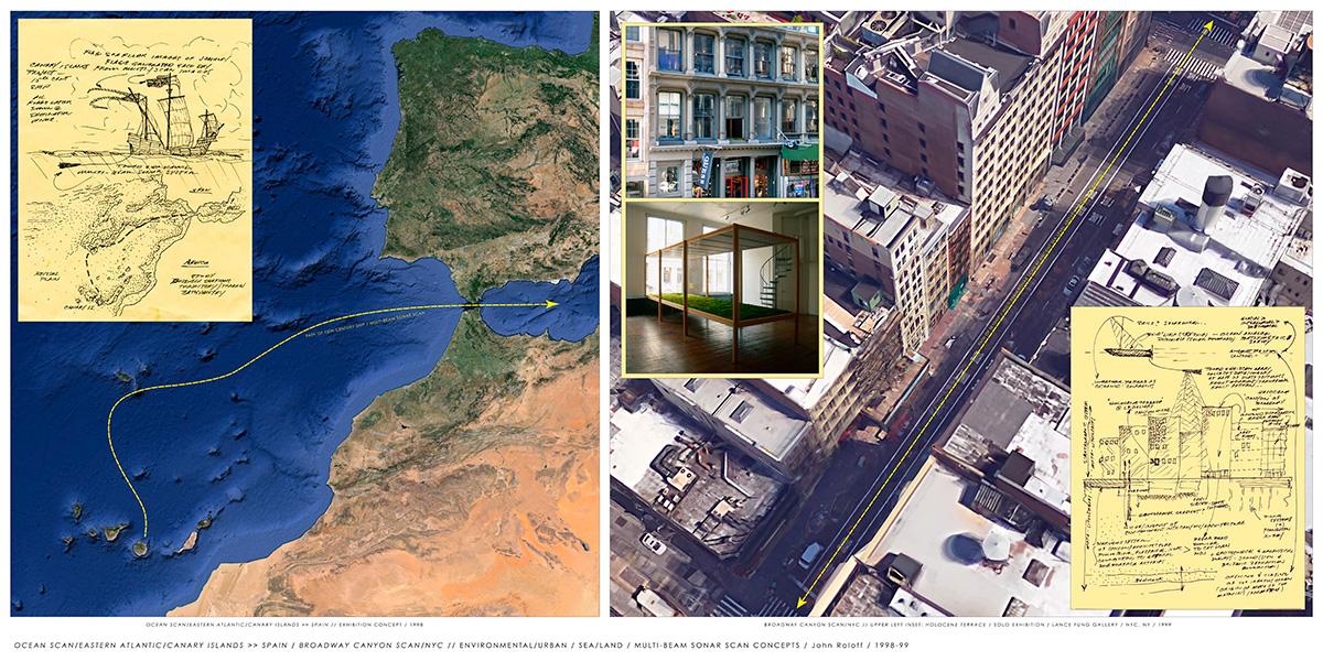
TOP LEFT:
Ocean Scan/Eastern Atlantic/Canary Islands >> Spain/Broadway Canyon/NYC.
Concept sketch/site bathymetric pathway
for Canary Island to Spain, towed multi-beam sonar, 15th century ship, flags, 1998; Broadway scan study for site near Lance Fung Gallery, NYC, related to the installation of Holocene Terrace, 1999.
Ocean Scan/Eastern Atlantic/Canary Islands >> Spain was specifically developed for a project for the Canary Islands from Ocean Scan 1998, a proposed project for a sailing ship on the open sea: each night of the journey the ocean floor is scanned using 'side-scanning radar' producing a visual profile of the bottom of the sea the ship is passing over. This profile is than printed by and on-board computer and printer onto mylar or Tyvek cloth and becomes the flag flying from the main mast on the following day. The flags accumulate so the entire night passage is displayed. After the journey, the flags are shown on land as an artwork.
Broadway Canyon/NYC examines the Anthropocene 'canyon' of Broadway, NYC, NY, as a geomorphological construct of human agency in a Sea/Land context using a LIDAR array (bathymetric side-scanning sonar analog) towed behing a dirgible "sky ship," similar to contemporary ROV ocean technology/systems. Conceived for the solo exhibition, Holocene Terrace, Lance Fung Gallery, Broadway, NYC, NY. Broadway is considered a "type formation," one of many canyons comprising major elements of the architectural geomorphology of the city. The inset of the sketch sheet (lower right) describes a range of site-scan concepts geologically contextualizing Holocene Terrace within the 'formation' of New York City by the use of oceanographic and geologic imaging systems.
The term "anthroturbation," developed in coversation with the USGS geophysicist, Paul Spudich, is used to describe the built environment as human disturbance of the landscape in geologic terms. The percption of New York City as a geologic formation was formally initiated in 1998 with the photographic work Franciscan/Manhattan Formation in the solo exhibtion, Dialogs with Nature, at the Lance Fung Gallery, NYC.
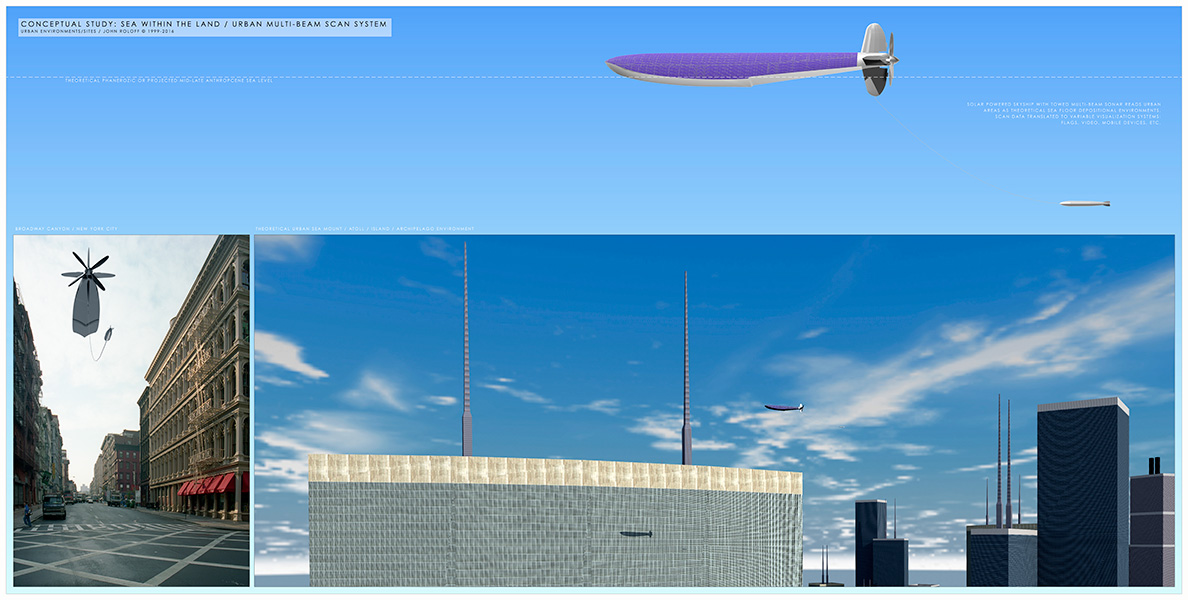
TOP CENTER:
Conceptual Study: Sea Within the Land/Urban Multi-beam Scan System.
At left: Broadway scan concept developed but unrealized as part of Holocene Terrace, solo exhibition at the Lance Fung Gallery, NYC, NY , 1999. At right - more recent study for sky ship/towed LIDAR array (multi-beamsonar scan analog) of urban environments at Phanerozoic or late Anthropocene sea levels, 2016.
The Broadway Canyon Scan/NYC concept is generalized to include other major urban sites as shown in the image on the right. These architectural/geologic "formations" were constructed by human agency analogous to geologic processes such as erosion (quarries), metamorphism (fired brick, etc) and deposition (masonry) with a generally rectilinear morphology similar to non-eroded geologic terrain and tectonic structures. The rate of deposition (construction) in this case is in human time while the erosion can be in geologic time (natural environmental denudation/transformation) or human time (deconstruction of the structure). The geologic history of a site in deep time can be considered as both land and sea: plate tectonics as well as terrestrial, marine, fluvial and lacustarine deposition invariably is part of that history. As part of the conceptual response to the site of Holocene Terrace, this thus-far unrealized bathymetric survey of the NYC assemblage was devised using a LIDAR array (side-scanning sonar analog) towed from a "sky ship" dirigible. As mentioned in the top central sketch related to this project, ground-penetrating radar further examines the internal architectural and sub-surface civic infrastructure. The skyship system would be operated at the level of actual or hypothetical "sea-levels" from the site's geologic past or Anthropocene future.
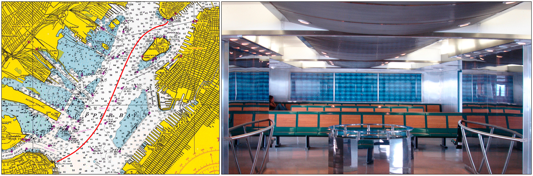
TOP RIGHT:
Le Milieu du Monde: The Middle of the World
Multi-media
installation on the bridge deck of each of three, Kennedy
Class, Staten
Island Ferries, New York, NY - 2000-06. Map image of the ferry route between Manhattan and Staten Island and corresponding side
scanning sonar video of the harbor bottom seen in sonar viewing apparatus shown to the far right. Concept and design by Werner Klotz and John
Roloff, production and installation by Werner Klotz.
Project Description 2001, updated 2007 by John Roloff.
One of two main elements of Le Milieu du Monde: The Middle
of the World, Sonar Space is located on the
Bridge Deck of each of the three new ferries. Within the Sonar
Space,
is the "Sonar
Portal," a
circular metal and glass housing inspired by nautical instruments.
Viewed within the structure is an animated image of the
passage between Manhattan and Staten Island as recorded by
a side-scanning sonar system of the harbor’s sea floor.
This image is perceived by the passenger as a daily "mandala" which
can also be viewed by a group of people as a shared experience.
On either side of the portal are reflective highly polished
stainless steel walls etched with the latitude and longitude
of the Manhattan and Staten Island Ferry Terminals, compounding
the social quality and walk-in instrument-like nature of this
transforming experience. The use of side scanning sonar as a visualization system came from the studies and research related to Holocene Terrace as described herein.
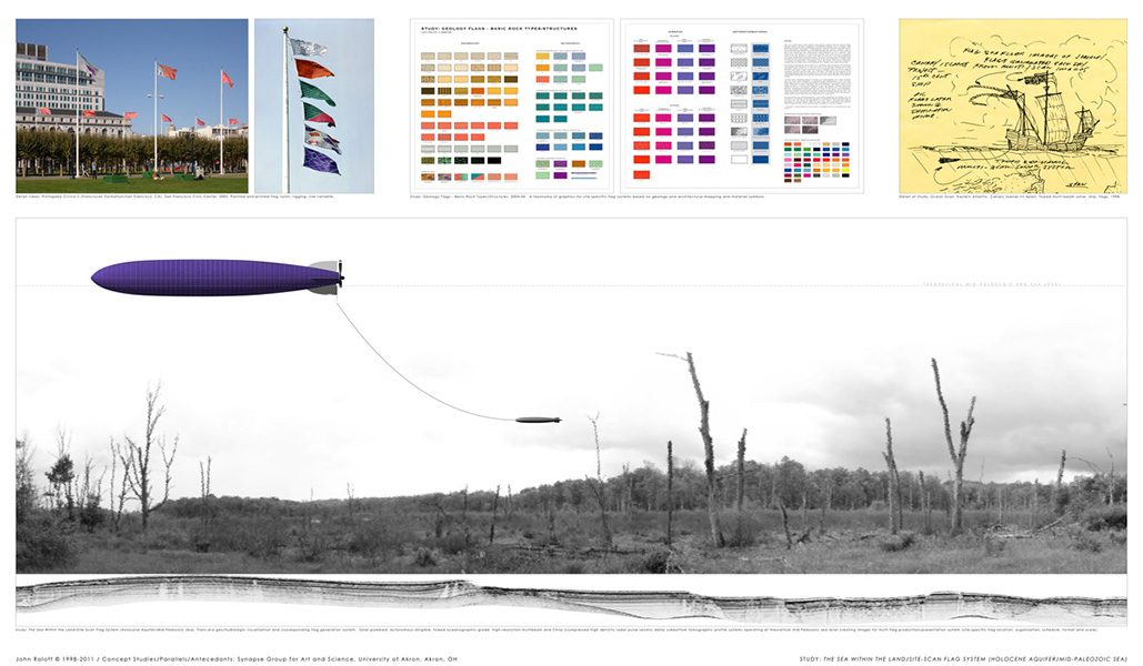
BOTTOM LEFT:
Study: The Sea within the Land/Site-scan Flag System (Holocene Aquifer/Mid-Paleozoic Sea)
Concept drawing for N. Ohio or related landscape, Synapse Group for Art and Science, University of Akron, OH, 2008-201.
A key notation in gray text on the right side of the main image along the dotted line: "Theoretical Mid-Paleozoic Era Sea Level." The altitude of "flight" or scanning may be taken from the geologic history of the site in terms of previous sea-levels related to the depositional environments of the terrain, plate tectonic history or anticipated Anthropocene sea levels, appropriate for the site. As part of the Sea/Land investigation discussed here and elsewhere, this proposal is also a variation of several projects, including: Study: Ocean Scan/Eastern Atlantic/Canary Island >> Spain, 1998 (shown on this page) and the Geology Flags projects, 2004-2006. The visualization system of the scan data may include: flags, banners, civic graphics, smart phone technology and other forms.
BOTTOM CENTER:
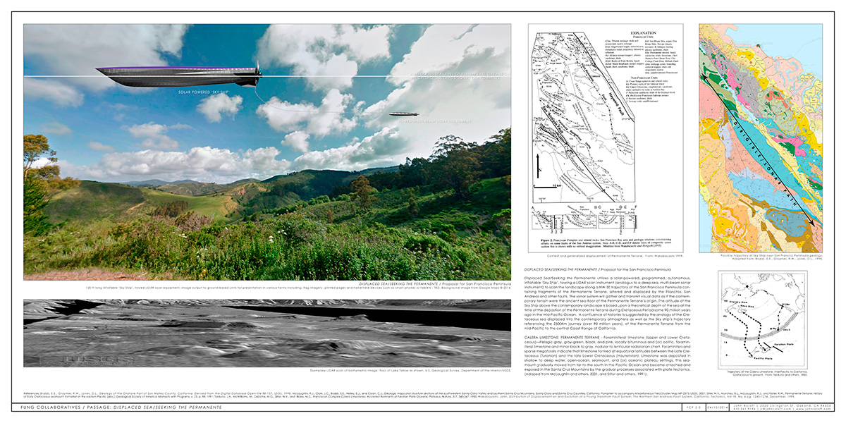
Fung Collaboratives / Passage: Displaced Sea/Seeking the Permanente
Proposal/concept drawing, ink-jet print on variable substrate, size variable, 2014. A proposal for Fung Collaboratives for a project in the mountains of San Mateo and Santa Cruz counties.
Displaced Sea/Seeking the Permanente utilizes a solar-powered, programmed, autonomous, inflatable ‘Sky Ship’, towing a LIDAR array (deep-sea, multi-beam sonar analog) to scan the landscape along a NW-SE trajectory of the San Francisco Peninsula containing fragments of the Permanente Terrane, altered and displaced by the Pilarcitos, San Andreas and other faults. The sonar system will gather and transmit visual data as if the contemporary terrain were the ancient sea floor of the Permanente Terrane’s origin. The altitude of the Sky Ship above the contemporary landscape is based upon a theoretical depth of the sea at the time of the deposition of the Permanente Terrane during Cretaceous Period some 90 million years ago in the mid-Pacific Ocean. A confluence of histories is suggested by the analogy of the Cretaceous sea displaced into the contemporary atmosphere as well as the Sky ship’s trajectory referencing the 2500Km journey (over 90 million years), of the Permanente Terrane from the mid-Pacific to the central Coast Range of California. The sonar imagery is processed and output to ground-based receivers, cell phones, printouts, flags, murals, etc., for tracking of the sky ship and visualization of the landscape as a function of complex geologic and oceanic dynamics.
Calera Limestone: Permanente Terrane
Foraminiferal limestone (Upper and Lower Cretaceous)—Pelagic gray, gray-green, black, and pink, locally bituminous and (or) oolitic, foraminiferal limestone and minor black to gray, nodular to lenticular radiolarian chert. Foraminifers and sparse megafossils indicate that limestone formed at equatorial latitudes between the Late Cretaceous (Turonian) and the late Lower Cretaceous (Hauterivian). Limestone was deposited in shallow to deep water, open-ocean, seamount, and (or) oceanic plateau settings. This seamount gradually moved from far to the south in the Pacific Ocean and became attached and exposed in the Santa Cruz Mountains by the gradual processes associated with plate tectonics. (Adapted from McLaughlin and others, 2001, and Sliter and others, 1991).
References: Brabb, E.E., Graymer, R.W., Jones, D.L., Geology of the Onshore Part of San Mateo County, California: Derived from the Digital Database Open-file 98-137, USGS, 1998; McLaughlin, R.J., Clark, J.C., Brabb, E.E., Helley, E.J., and Colón, C.J., Geologic maps and structure sections of the southwestern Santa Clara Valley and southern Santa Cruz Mountains, Santa Clara and Santa Cruz Counties, California, Pamphlet to accompany Miscellaneous Field Studies Map MF-2373, USGS, 2001; Sliter, W.V., Murchey, B.L., McLaughlin, R.J., and Kistler, R.W., Permanente Terrane: History of Early Cretaceous seamount formation in the eastern Pacific [abs.]: Geological Society of America Abstracts with Programs, v. 23, p. 98. 1991; Tarduno, J.A., McWilliams, M., Debiche, M.G., Sliter, W.V., and Blake, M.C., Franciscan Complex Calera Limestones: Accreted Remnants of Farallon Plate Oceanic Plateaus, Nature, 317, 345-347, 1985; Wakabayashi, John, Distribution of Displacement on and Evolution of a Young Transform Fault System: The Northern San Andreas Fault System, California, Tectonics, Vol 18, No. 6 pg. 1245-1274, December, 1999.
BOTTOM RIGHT:
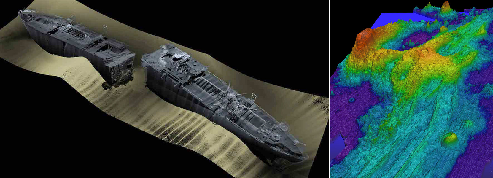
Multi-beam Survey of Liberty Ship Richard Montgomery. NOAA Advanced Underwater Surveys / Exaggerated swatch Bathymetry of Axial Seamount. NOAA sonar scan of Axial Seamount.
These images represent two forms of visualization capability of contemporary multi-beam and related sonar scanning systems. The use of false color to indicate topographic and other information is a common practice. Other forms of tomographic imaging includes may other such as: ground penetrating radar, geophysical seismic/sound systems at the macro and global level, as well as numerous forms of small-scale imaging/data ranging from electron microsopy, laser-based imaging, CT scan-like x-ray, MRI, x-ray crystallography and many others. Many these imaging techologies are deployed using GPS guided, programmed, human interaction, sensor-driven and related interfaces. All these technologies can be implemented at different scales for site, conceptual and poetic visualization of the Sea and Land..
|